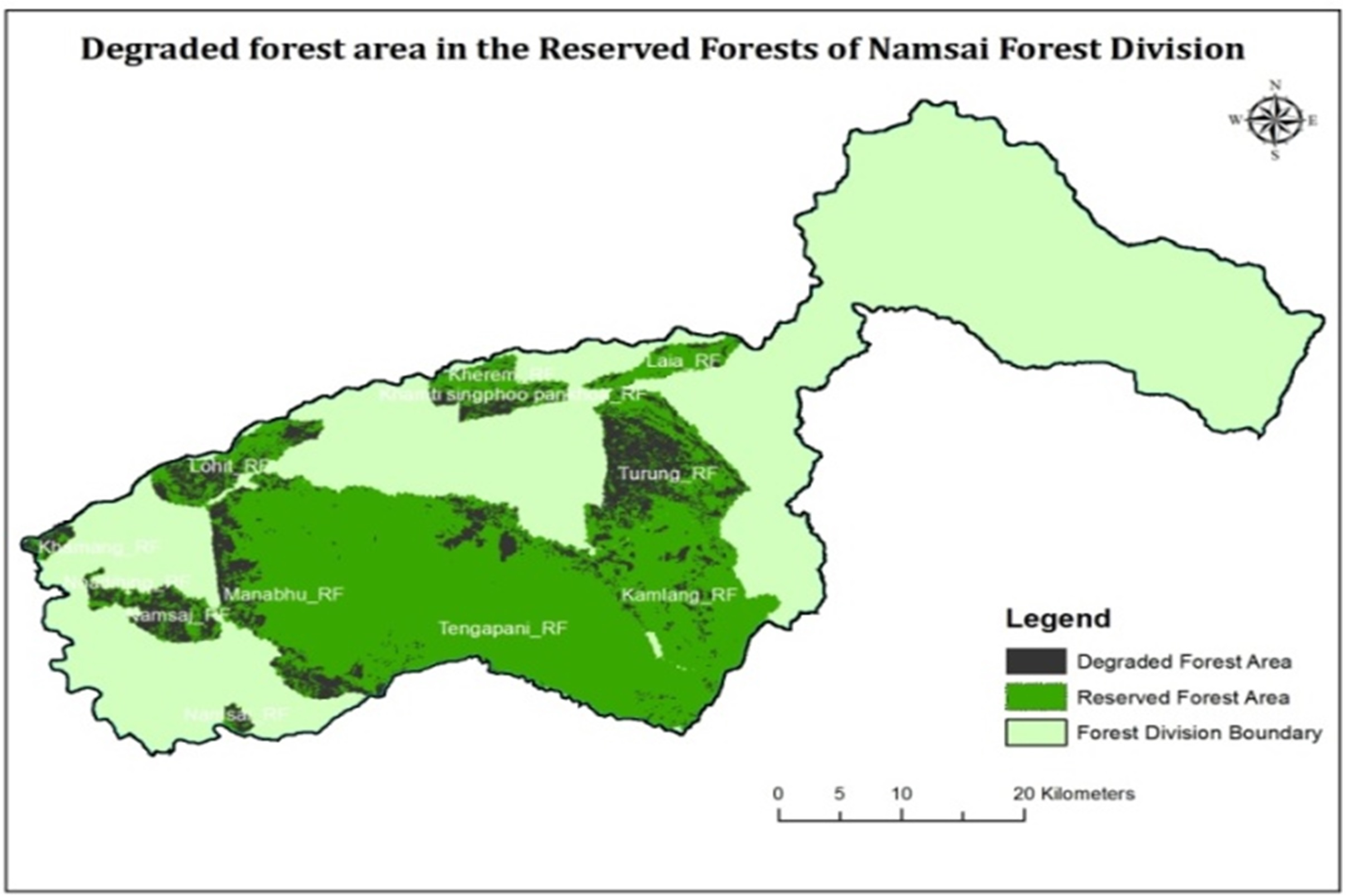
Forests constitute about 65.45% of the total geographical area of northeastern India. This region represents 24.22% of the country’s forest cover (FSI, 2017) although it occupies only 7.98% of the country’s land area. Forests of this region are structurally unique and diverse owing to its location in the transition zone between the Indian, Indo-Malayan and Indo-Chinese biogeographic region and the altitudinal variation and rainfall patterns of southwest and northeast monsoon in the region also play a significant role. But these forests are under immense pressure as the ownership is mostly under the community, clan or private and little under the control of the States. The State Forest Departments of the region had been preparing the forest working plans for the divisions where no approved working plan exists and revising for those which are expiring. NESAC has been supporting different state forest departments in preparing the geospatial inputs and computational estimates of growing stocks at forest compartment level. Studies on vegetation and soil carbon, bamboo resources, forest biomass estimations, wetlands mapping, shifting cultivation dynamics and burnt area assessment are some of the other activities of this group.
Forestry and Ecology
Applications Area
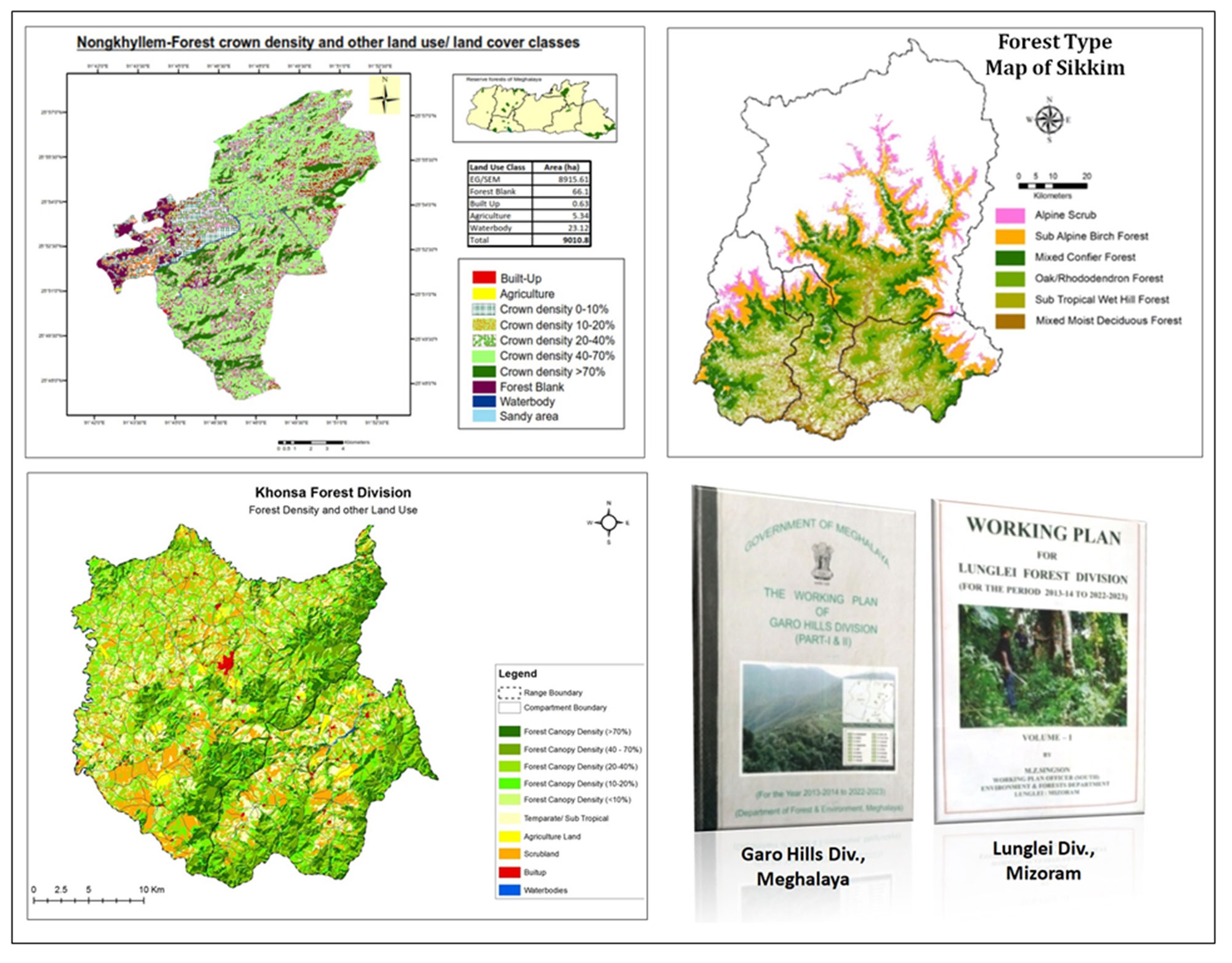
Ministry of Environment and Forests and Climate Change (MoEFCC), Govt. of India adopted National Working Plan Code in 2014 for the management of forests under the prescriptions of a working plan/schemes prepared on the basis of principles of sustained management of forests and recognized silvicultural practices. Accordingly, exercise for RS&GIS base forest working plan input preparation has been taken up for the states of Arunachal Pradesh (entire State), Assam (21 divisions), Meghalaya (entire State) and Mizoram (Entire State) in collaboration with the respective State Forest Departments. The working plan for 27 reserve forests of Meghalaya distributed in three working circles has been approved by MoEFCC. The bamboo working scheme for NC Hills Forest has been approved. The working plans for the Lunglei, North Vanlaiphai, Kolasib, Thenzawl, Aizawl, Chakma ADC and Darlawn divisions of Mizoram has also been approved by MoEFCC and the works for preparation of other geospatial inputs for other divisions of the states is underway.
These projects are being taken up to help the state forest departments in the preparation of division wise forest working plans. NESAC provided the necessary geospatial inputs and computational estimations of timber growing stocks at different administrative/management units to support the forest department in formulating the silvicultural prescriptions for conserving and managing the forest for next 10 years. It benefits the Forest Department of the respective states in preparation of Forest working Plans. The direct users are the State Forest Departments who submits the working plans to the MoEFCC for approval. Email director[at]nesac[dot]gov[dot]in may kindly be contacted for further details on the projects.
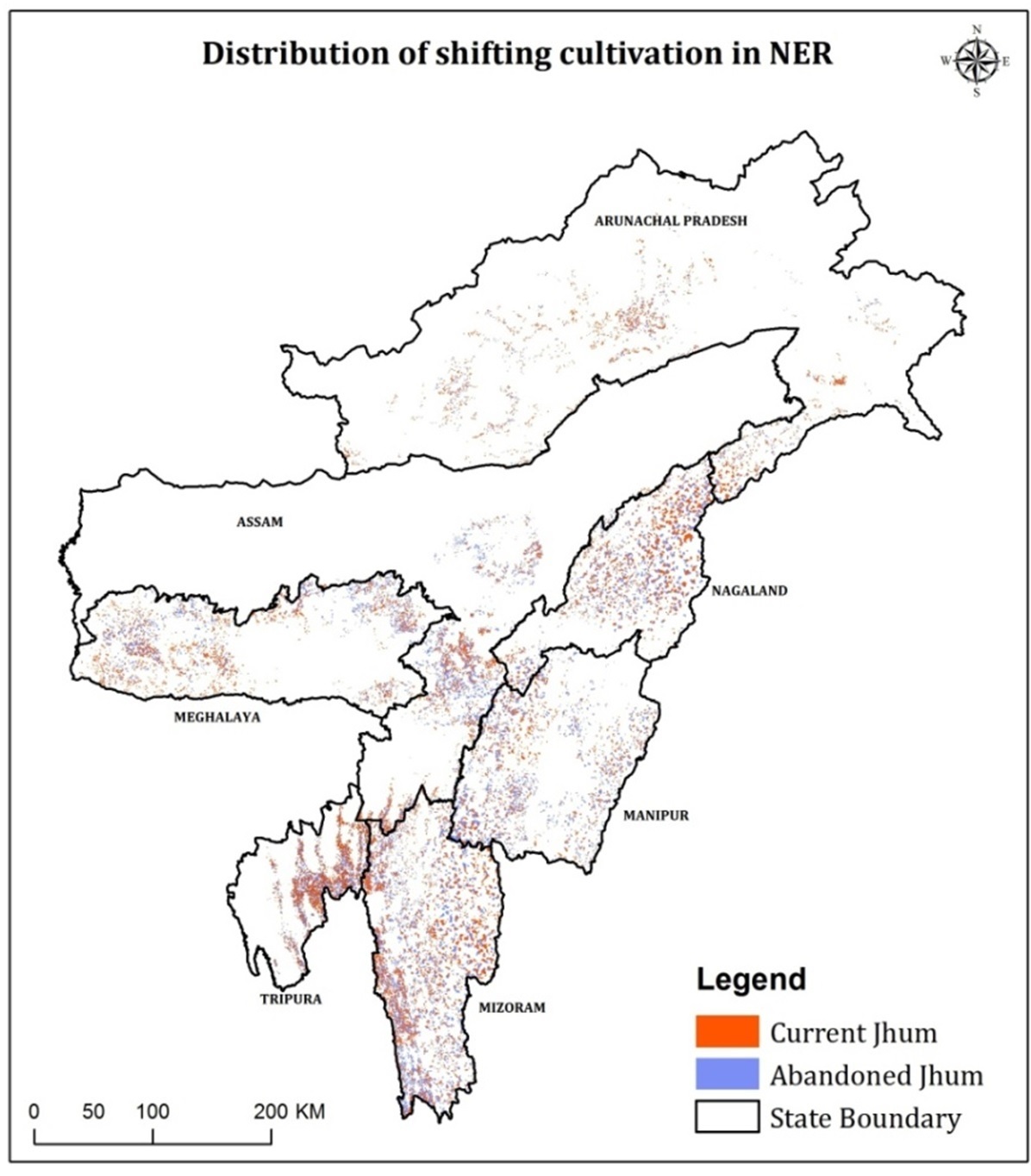
Areas under shifting cultivation practice in the region were mapped at different scales (1:50K, 1:25K and 1:10K) as per the data availability and requirements. Annual area under shifting cultivation has been monitored for the past five years for the region and time series data analysis to monitor the jhum fields have been done for selected districts.
The need for updated information on area under jhum was felt from different line departments and related central government organizations during the State Level Meets conducted earlier and unavailability of relevant data. So mapping was done at smaller scale to generate the latest information on jhum. Later as per the requests from Ministry of Agriculture and Farmers Welfare, Govt. of India, and NITI Aayog, the status of area under shifting cultivation in the region and the number of jhumia families depending on it has been estimated/ derived based on spatial analysis and field sample surveys, with 2019 as the base year for mapping. Many line departments like Forest Department, Agriculture Department, Horticulture Department, Soil and Water conservation, Tribal Welfare etc. south these data for planning their activities in identifying and projecting the fallow area to be developed. Email director[at]nesac[dot]gov[dot]in may kindly be contacted for further details on the projects.
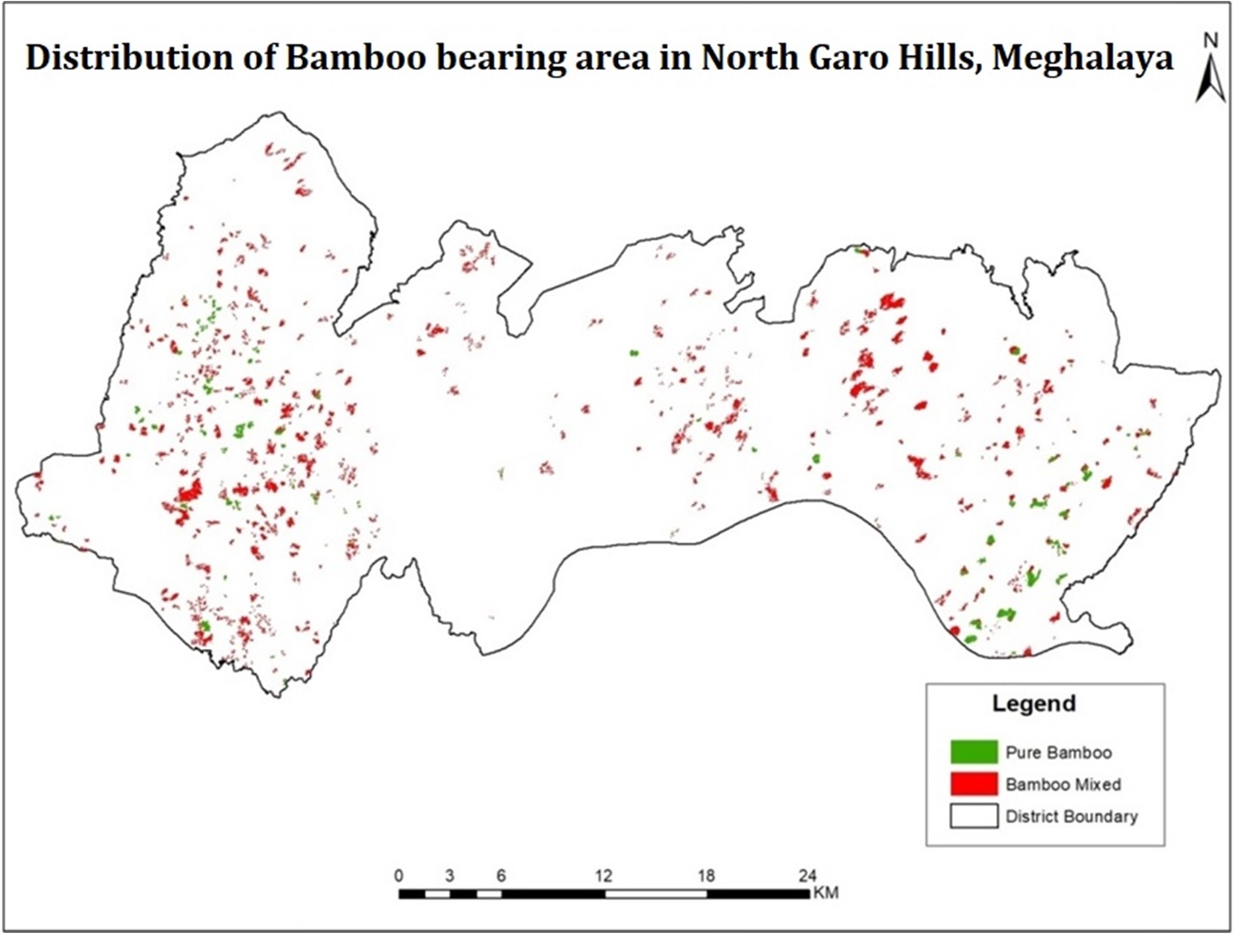
The northeast, comprising of 8 states covering 7.97% of India’s Geographic Area but grows 67% of India’s bamboo. North Eastern Himalayan region of India has great diversity of bamboo resources. Dense bamboos are found mostly in Arunachal Pradesh followed by Mizoram and Manipur. In order to assess the bamboo resources of the region NESAC undertook the mapping of bamboo resources of Arunachal Pradesh in collaboration with SFRI, Itanagar during 2005-06. To assess the extent of bamboo flowering during 2006-2008, a project was conducted with MIRSAC, Aizawl to study the dynamics of bamboo flowering during 2005, 2006 and 2008. Detailed estimates of bamboo in different bamboo working circles of Dima Hasao district of Assam was also done at NESAC and based on the exercise, the Bamboo working scheme for the district was approved by MoEFCC, Govt. of India. Spatial distribution of bamboo resources in six districts of Nagaland was mapped using high resolution IRS LISS IV imagery to assess the availability of raw materials for the Nagaland Pulp & Paper Company Limited, Tuli, Mokokchung, Nagaland (2010). A pilot study on mapping of bamboo growing stock in Mokokchung and Wokha districts were done under NESAC-TDP along with Nagaland University involving large scale mapping and stock assessment based on field data (2017-19). Currently bamboo resource mapping for Meghalaya is on going with funding from Soil and Water Conservation Dept., Govt. of Meghalaya, the results of which will be used for planning purpose under National Bamboo Mission. Email director[at]nesac[dot]gov[dot]in may kindly be contacted for further details on the projects.
The Northeast region of India is rich biodiversity and highly significant as it lies at the confluence of the Indo-Malayan, Indo-Chinese and Indian biogeographically realm and it supports diverse floral and faunal diversity. The region is also home to a large number of rare, endemic and endangered wild animals. However, the habitats of the wildlife are under severe threats due to depletion, degradation and fragmentation of forest cover and loss of corridors for the movement of the wildlife. The fragmentation of habitat and loss of animal corridors have consequently led to an escalation in animal–human conflict.
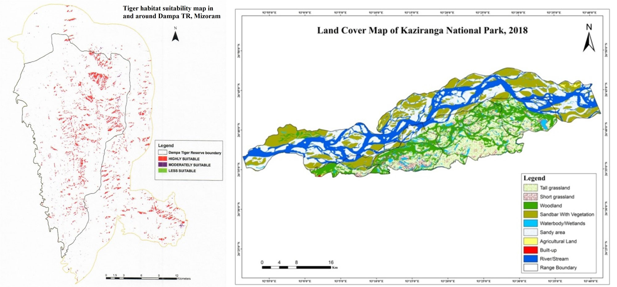
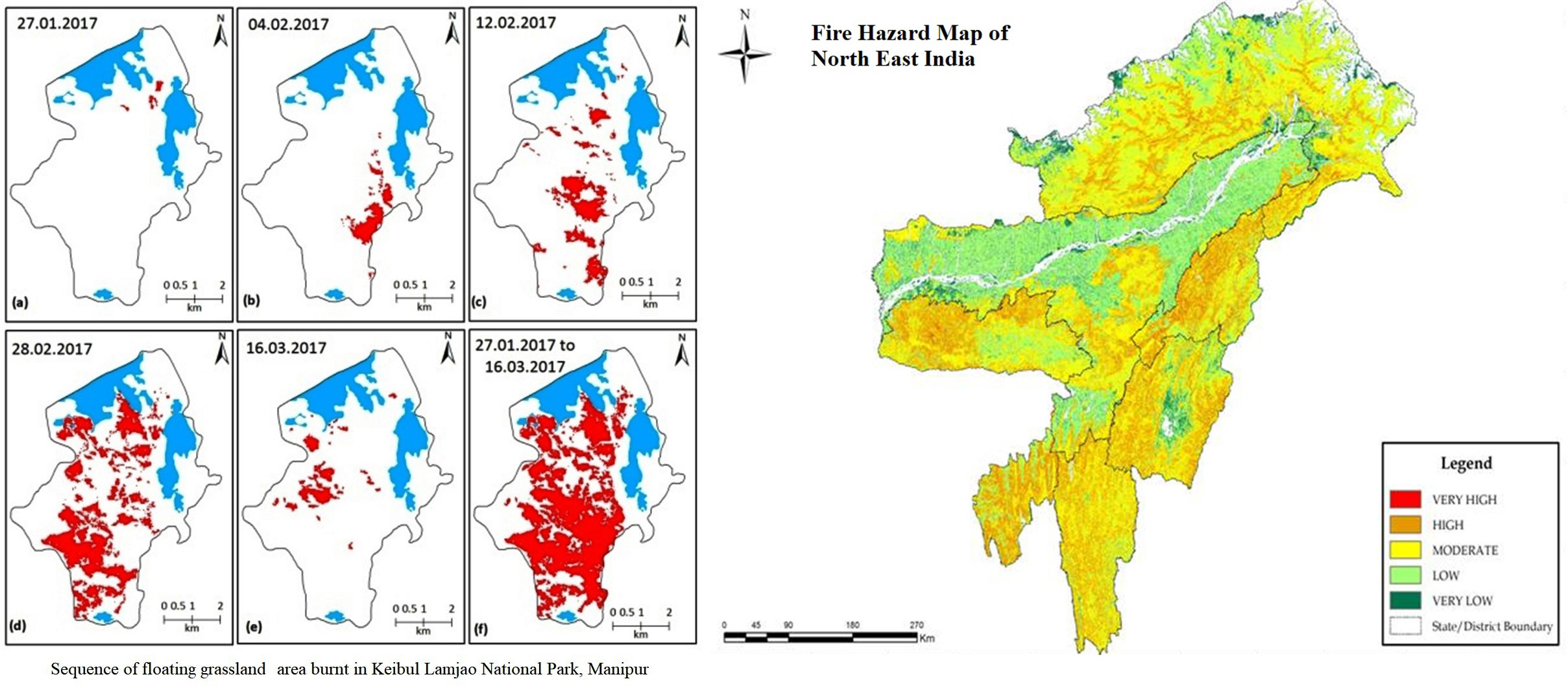
Towards management of wildlife habitat in NER region, studies on mapping the suitable habitat of elephant (Rani & Garbhanga RFs, Assam) and tigers (Dampa Tiger Reserve, Mizoram) have been carried out. The elephant habitat study had been undertaken in collaboration of the Environment and Forest Dept., Govt. of Assam. Habitat suitability for tiger and elephants were mapped and potential corridor for the movement of elephant has also been identified. These projects were taken up as part of R&D projects of NESAC. Apart from this the wildlife habitat mapping was done for Keibul Lamjao National Park (KLNP), Manipur and grassland burnt area of the floating meadows in KLNP was also done on the request from the state forest department and Wildlife Institute of India.
The project reports have been submitted to the concerned State Forest departments for utilization in the preparation of management plans. The generated information can also prove potential to varied sections of academia for further research in the field. Email director[at]nesac[dot]gov[dot]in may kindly be contacted for further details on the projects.
A pilot study was carried out in R&D mode to analyse the distribution pattern and variation in vegetation phenology for several natural vegetation types in North East India using time series satellite data. This will help in understanding the vegetation composition pattern and aid in classification of forest types. MODIS’s 16 days’ composite NDVI time series data for a period of 18 years has been analysed for the NER. After smoothing the data, phenological parameters were computed by defining the threshold for the start and end of seasons. Seasonality parameters such as start of the season, the end of the season, length of the season, base level, mid of the season, maximum NDVI value and seasonal amplitude have been calculated. Satellite based derived vegetation phenology has been analysed and correlated with the major forest types found in the region. Email director[at]nesac[dot]gov[dot]in may kindly be contacted for further details on the projects.
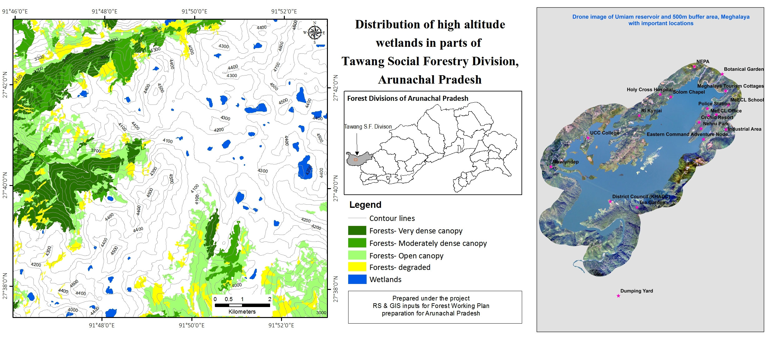
Wetlands are important ecosystems on the earth surface providing important ecological services. A number of projects are being carried out on wetland studies. Few of which are wetland biodiversity mapping of Deepor beel, National wetland Inventory and Assessment (NWIA), land use/ land cover mapping in Deepor beel catchment using high resolution satellite data, land use /land cover mapping of Diplai beel, catchment area delineation of wetlands, mapping of wetlands using drone (UAV) survey. Under Forest Working Plan project too, wetlands for the state of Arunachal Pradesh were mapped at 1:10K scale and have been provided to the Environment Directorate and Rural Development departments of Arunachal Pradesh, as per their requirements arising out of the Supreme Court directive to conserve the wetlands and form a policy for protecting the wetlands. The wetland mappings that are being carried out, generates spatial and temporal wetland database, change detection analysis, etc. The datasets are used by policy makers for fishery development, flood mitigation, tourism development, rural development planning, etc. Email director[at]nesac[dot]gov[dot]in may kindly be contacted for further details on the projects.
Forest fires are one of the major causes of deforestation and forest degradation. North Eastern region witness several forest fire incidents each year. Value added forest fire location alerts are generated and disseminated during forest fire season. Forest fire vulnerability map has been generated for entire northeast India. The burned area maps are generated for selected areas for forest fire management.
The forest fire inputs are used by respective state forest departments for management of forest fires in northeast region. The forest fire vulnerability maps are important inputs to understand the areas affected by forest fires. The forest fire alerts can help to support State Forest Departments and State Disaster Management Authority during forest fire season. The forest fire burned area maps help to estimate the extent of fire. As per the requests from the departments the burnt area maps are prepared for specific areas for formulating policies and planning for mitigation and managing the fires. Email director[at]nesac[dot]gov[dot]in may kindly be contacted for further details on the projects.
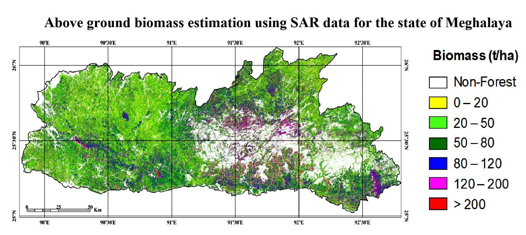
Satellite remote sensing plays an important role in the forest biomass mapping due to large area coverage. The use of microwave remote sensing plays an important role in forest biomass estimation in high biomass region. Under this research project, forest above ground biomass map of selected places of the region has been mapped. This map will be useful for understanding the spatial distribution of forest biomass more meaning fully which can ultimately help in effective forest management. Email director[at]nesac[dot]gov[dot]in may kindly be contacted for further details on the projects.
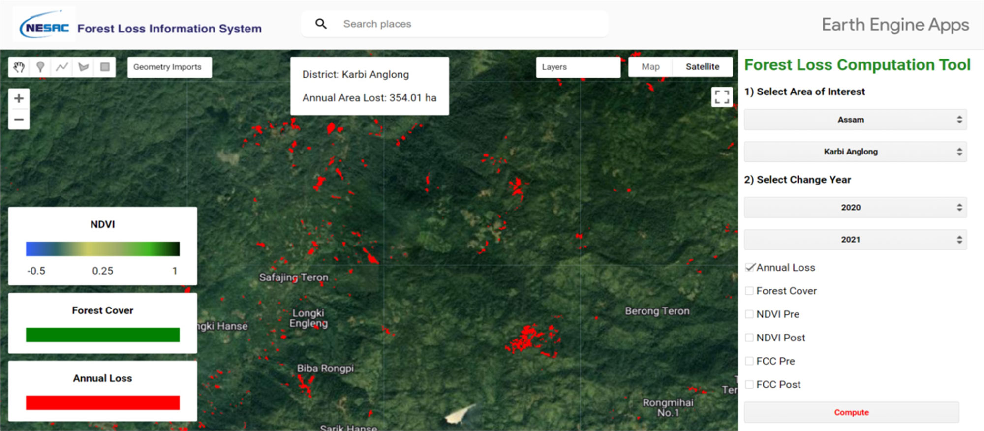
Forest has been an integral part of human being. The north east region of India is also India’s greenest region, which is also encountering deforestation activities. Many agencies and forest department are interested to know the loss in forest covers within their administrative area. Thus this project aimed to develop an automated system for monitoring of deforestation. It is a web application which will give the information about the area deforested within a time period and generate stats at district level of north eastern states.
For identification of forest cut, NDVI was computed between two time periods. The pre and post time period images (Sentinel-2) were taken representing before and after deforestation. The images of pre and post time periods were taken from the same month so that phenological variation can be neglected. Difference between NDVI of two periods was computed and threshold was set to identify change in the forest status. The entire process was developed on Google Earth Engine Platform and web application has been developed for continuous monitoring. Annual forest loss product can be generated at district level using the developed web application. Email director[at]nesac[dot]gov[dot]in may kindly be contacted for further details on the projects.
Forest in the NE region is rich in biodiversity. These forests also harbour aromatic and medicinal plants. The indigenous people from this region are also dependent on these medicinal/ economically important plants. However, it is under severe pressure due to human interference such as illicit logging of trees for timber and firewood and expansion of human habitation. As a result, forest cover in the region is disappearing at an alarming rate. Therefore, understanding the spatial distribution of these plants are very essential for conservation and also in identifying suitable sites for reintroduction.
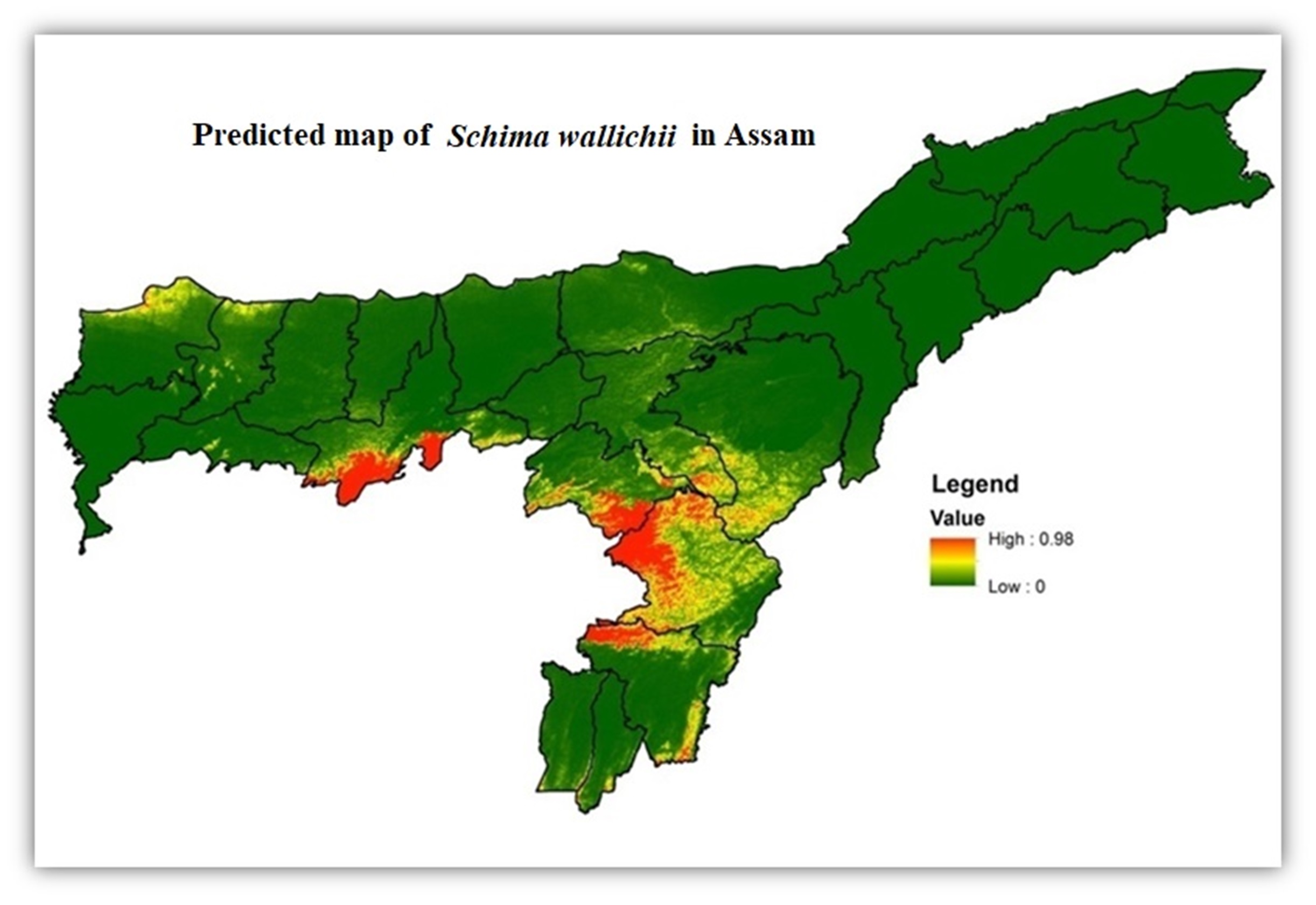
A pilot study was carried out at Mawphlang and Pynursla blocks of East Khasi Hills District of Meghalaya to understand the spatial distribution of the medicinal and aromatic plants. Potential sites for some of the medicinal and aromatic plants have been identified using MaXent and it provides a maximum-entropy approach for species habitat modeling and takes as input a set of layers or environmental variables (such as elevation, temperature, rainfall, etc.) along with a set of georeferenced occurrence locations and produces a model of the range of the given species. Similarly, potential site for Schima wallichii was also identified using MaXent and it was found that in Kamrup, N C Hills, Karbi Anglong Cachar and Nagoan districts of Assam is highly suitable for the species. This type of studies can be taken up in other parts of the region and will be useful for further research on vegetation distribution in relation to climate change. Email director[at]nesac[dot]gov[dot]in may kindly be contacted for further details on the projects.

