Photogrammetry and UAV division provides complete solutions for all standard tasks in digital Photogrammetry services such as Aerial Triangulation (AT), DSM/ DTM generation, Photogrammetry mapping, stereo compilation, topographic and planimetric feature extraction, orthophoto production, color balancing, contour generation, alignment studies for canal/road/railways, cut and fill volume estimation – volumetric analysis, L-section & cross-section profile generation, 3D terrain visualization and photo-realistic 3D city modeling.
Photogrammetry & UAV Applications

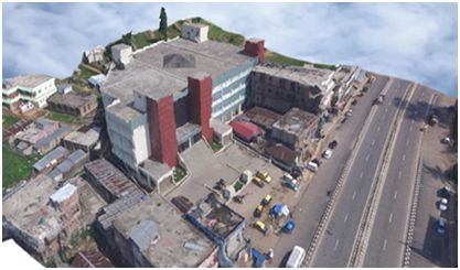
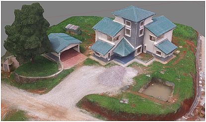
NESAC has also entered a new era – UAV Photogrammetry imaging applications. UAVs (Unmanned Aerial Vehicles), also called as drones are nowadays commonly using as platforms for acquiring aerial imagery due to cost efficient over small areas and more flexible for deployment which otherwise alternative to the conventional manned aerial Photogrammetry.
UAV Photogrammetry is a new photogrammetric measurement tool which opens various new applications in the close-range Photogrammetry domain, combining aerial and terrestrial Photogrammetry. UAV Photogrammetry is being accommodate in various applications ranging from large scale building modelling to vegetation structure mapping which can greatly benefit for local planning and development especially in North Eastern region with very limited connectivity and physical infrastructure. The expertise in NESAC includes UAV Aerial Surveys, Ground Control Surveys, Value-added Services & providing Complete Solutions such as Utility GIS, Close contour mapping and DSM/ DTM generation using point cloud data, Orthophoto production, 3-D feature reconstruction and visualization.