Among the natural disasters, flood is one of the most common and widely spread disasters across the world. In India, the north eastern state of Assam is one of the most complex fluvial systems of rivers mainly with two inter-connected river valleys namely Brahmaputra and Barak which together enters the bay of Bengal. In 2009 NESAC has initiated Flood Early Warning System for Assam as a pilot exercise for Lakhimpur. Presently it is operationalized for all the districts of Assam.
The state of Assam is fully covered by the Brahmaputra and Barak basins. A severe flood event affected Lakhimpur district of Assam during June, 2008 causing enormous damage. NESAC was formally requested by Govt. of Assam and the North Eastern Council (NEC) to develop an flood warning system using geospatial technology coupled with satellite and ground based hydro-meteorological analysis for issue of actionable alerts and advisories to state and district administration for risk reduction and management of flood in Assam. The project FLEWS was initiated for Lakhimpur district as pilot during 2009-10. At present the project covers all flood prone districts of Assam with actionable flood alerts in revenue circle level. All these years since the beginning, an average year to year alert success score of 75% and an average alert to alert lead time of 12 to 36 hours have been maintained. On completion of the second three year operational period from 2015 to 2017, action has been taken for the third operational period from 2018 to 2020 at the request from Government of Assam.
The technical component of this exercise comprises of two sub component namely the numerical rainfall prediction model called the Weather Research Forecast (WRF) supported by a qualitative synoptic weather monitoring exercise and a GIS based distributed hydrological model known as the Hydrologic Engineering Centre – Hydrologic Modeling System (HECHMS). While the first sub component, predicts the rainfall values in different grid resolutions such as 27 km, 9 km, and 5 km at three hourly interval for coming 24 hour period, the second sub-component intake the predicted rainfall values into a spatially distributed mesh of inter-connected hierarchy of watershed runoff models giving predicted values of peak discharge as well as hydro-graphs which in turn is compared with established flooding threshold discharge values of the river or tributaries concerned in order to generate the flood alerts and disseminated accordingly to the revenue circles and district concerned in terms of simple flood advisories with satellite images pertaining to the concerned revenue circle and district lying in the flood plain under the said flood alert. During the monsoon 2017 the overall success of 86% (absolute and partial combined) was achieved.
Being the first operational GIS based hydro-met warning system in the country, this scheme of NESAC has been able to get both national and regional level recognition such as Good Governance Initiative and professional best practiceby Union Ministry of Public Grievances and Pensions, Govt. of India as well as winner of E-North East award for E-governance and Citizen services delivery etc. This scheme has generated enough interest in the country that a good numbers Parliament questions (both from LOK SABHA & RAJYA SABHA) have been answered by NESAC / ISRO on this scheme.
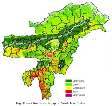
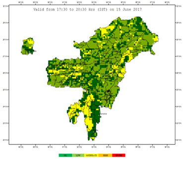
Under the North Eastern Regional node for Disaster Risk Reduction (NER-DRR), value added forest fire products are being disseminated to all the concerned forest departments and local level NGOs via email. Similar to the previous years, forest fire alerts have been provided during the fire season in the year 2018. In addition to the email alerts, the fire alerts are updated in the website also. The fire alerts contain map showing the distribution of fire location along with information on the fuel characteristics, proximity to settlement, water bodies, road connectivity and current weather formation. Extensive field verification in the fire affected areas have been carried out.
Landslides are important denudational processes in mountainous areas that frequently damages means of communication and transportation besides creating loss to the life and property. Detection of landslide and identification of the affected area is a key requirement for planning post-disaster rescue and relief operations as well as landslide susceptibility and hazard assessment. NESAC has prepared landslide hazard zonation, vulnerability assessment, risk assessment maps has been prepared for Guwahati city.

Thunderstorm is one of the major disasters affecting the entire NE region and particularly the states of Assam, Tripura, Mizoram and Meghalaya. There are severe loss of life and property from the thunders and associated wind every year over these regions. Early warning of thunderstorm with actionable lead time has the potential to save these lives and minimize loss of property. NESAC has initiated thunderstorm now casting on experimental basis for the western Assam, Meghalaya, Mizoram, and Tripura states during the pre-monsoon season of the year 2016.
 Severe thunderstorms (TS) associated with lightning is one of the major life threatening disaster over the NER of India. TS nowcasting services are being provided from NESAC since 2014 on pilot basis for the states of Meghalaya, Tripura, Mizoram, and parts of Assam. The same was extended to entire NER of India since 2017 under the NER-DRR initiatives at NESAC.
TS Nowcasting is provided in two forms, first by preparing a thunderstorm potential map based on numerical weather prediction model outputs, and then by preparation of thunderstorm bulletins based on real time weather watch using data from Doppler weather radar, Satellites, and automatic weather stations. The services are provided from 15th March to 15th June every year, as frequency of TS is highest during this period.
The TS bulletin and potential map was issued thrice daily with TS bulletin having validity of four hour and TS potential map having validity of three hours. The TS potential map uses WRF model based forecast of atmospheric instability indices (like convective available potential energy, convective inhibition energy, K index, Lifted Index, etc) and relative humidity. The TS potential map predicts the potential location where thunderstorm occurrence is likely during a given time. TS warnings in both TS bulletin and potential map is categorized in five category (Nil, Low, Moderate, High, and Severe) based on the likely intensity of the thunderstorm. The TS potential index and the warnings are validated using observed data (Satellite, DWR, IMD reports, etc). The accuracy of thunderstorm potential mapping for the complete pre-monsoon season revealed highest accuracy over the Arunachal Pradesh and lowest over Tripura, Mizoram, and southern Assam. The probability of detection and false alarm ratio for the TS bulleting for the full season was found to be 0.89 and 0.46 respectively.